

How an Earthquake in Russia Had Us Worrying About Our Boat in Tahiti
4 min read
We were still laying in bed, scrolling through the news, when a headline made us pause:
“Magnitude 8.8 Earthquake Strikes Off Russia’s Kamchatka Peninsula - Tsunami Warnings Across Pacific.”
Wait! French Polynesia? Is our boat in Tahiti safe?
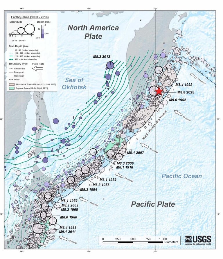
The earthquake had struck the evening before, on July 29 at 7:25 pm EDT, near Petropavlovsk-Kamchatsky, a city on Russia’s remote Kamchatka Peninsula. At magnitude 8.8, it tied for the sixth strongest quake ever recorded by modern instruments.
The quake occurred in a subduction zone, where the Pacific Plate is forced beneath the North American Plate. That is a tectonic collision zone known for producing the world’s most powerful earthquakes. This one ruptured a massive stretch of fault line, about 390 km long and 140 km wide, and occurred at a shallow depth of just 19 km (12 miles) in the subduction zone of the Earth's crust. That shallow depth is important, since it allows more vertical displacement of the seafloor and that is exactly what’s needed to generate a tsunami.
Why a quake in Russia matters to a boat in Tahiti
Tsunamis are different from normal waves. They’re caused not by wind, but by sudden seafloor movements, like when a chunk of the ocean bed is shoved upward by a quake. That movement displaces massive amounts of water and sends long, fast waves racing across the ocean.
Unlike surface waves that only affect the top layer of the ocean, tsunami waves move through the entire water column, from the seafloor to the surface. That’s why they can travel so far, and so fast, at up to 800 km/h, the speed of a jet plane. And they don’t lose much energy along the way.
So when the earthquake hit, tsunami warnings didn’t just go out for Russia. They were issued across the Pacific: Japan, Hawaii, Alaska, Chile, and French Polynesia. The Marquesas Islands were put on high alert. Residents were urged to move to higher ground, with warnings that waves could reach 2.5 meters (8 feet).
What can you do when your boat is in a tsunami zone?
Tsunamis are especially dangerous in harbors. The narrow, shallow spaces amplify wave height and funnel energy, making it easier for moored vessels to break loose, collide, or be carried inland.
Counterintuitively, boats are often safer out at sea in deep water, where the tsunami wave may only raise the surface by a few feet and pass under the hull unnoticed. But that’s only if the boat is already offshore. If you're in port when a tsunami warning is issued, it's usually too late to safely head out and too dangerous to try.
For us, being thousands of kilometers away in Colorado, there wasn’t much we could do except wait and hope. Had we been there, we might’ve sailed Tauha to deep water, but we weren’t. She was tied up, resting at her mooring, completely out of our hands.
What happened in the end?
Thankfully, while tsunami waves did hit the Marquesas, they were smaller than expected, less than 1.5 meters high. Authorities lifted the alert later that day, though they encouraged continued caution. In Tahiti, conditions remained stable. Tauha was fine. The port was fairly calm. Our nerves settled.
The science behind the shake
Backed by global seismic networks like the Advanced National Seismic System (ANSS), this earthquake was recorded by seismographs all over the world. These instruments detect ground movement using a mass suspended on springs. As the Earth moves beneath it, the mass stays in place, due to inertia, and sensors record the motion.
The readings, called seismograms, help scientists quickly determine the location, depth, and strength of a quake. The Moment Magnitude Scale (Mw) is now the standard for measuring quake size. It’s more accurate than the old Richter scale, especially for large quakes like this one, because it accounts for the total energy released, not just the strongest shaking at one location.
The ripple effects didn’t stop with waves. Not long after the earthquake, Klyuchevskoy Volcano, located about 450 km from the epicenter, began erupting. This isn’t unusual. If a volcano already has magma and pressure built up, an earthquake can trigger an eruption, like popping the lid off a shaken soda bottle.
Why wasn’t the tsunami worse?
Several factors likely helped. The height of a tsunami's waves depends on more than the quake’s magnitude. The exact depth of the rupture, the shape of the seafloor, and the topography of coastlines all influence how much water is displaced and how waves behave when they arrive.
In this case, scientists think the tsunami models may have used conservative estimates for safety, which is good. Better to warn early than be caught off guard.
A quiet boat, a moving Earth
For us, this event was a crash course in tectonics, tsunami physics, and boat safety, all wrapped in one long morning of anxious scrolling. It’s easy to forget how interconnected everything is, until a quake on the other side of the world sends you checking tide charts and port webcams in the South Pacific.
Earthquakes may be local, but their effects ripple far. And when you live with one foot on land and the other in the sea, you need to stay alert for wind, waves, and sometimes even plates shifting on the other side of the planet.
If you’d like to read more, follow our journey, and support what we do, don’t forget to subscribe to our newsletter or follow us on social media. Every bit of encouragement helps keep the adventure going and we’d love to have you aboard!