

Hurricanes, Typhoons & Cyclones
These powerful storms may go by different names, but they all start the same way. Learn how, when, and why tropical cyclones form and what that means for ocean travel.
🌴 Hurricane comes from the Taíno people of the Caribbean, who spoke of Huracán, the god of storms and chaos. Spanish colonists picked up the word, and it stuck.
🌬 Typhoon likely has Chinese roots. In Mandarin, tàifēng (大风) means "great wind." But it also echoes the ancient Greek Typhôn (Τυφῶν), a monstrous storm giant.
🌀 Cyclone is the most literal of them all. It comes from the Greek word kúklos (circle) or kuklóō (to go around in a circle), describing the spinning motion of these storms.

Hurricanes, typhoons, and cyclones might be the same kind of storm, but their names come from very different places and each one tells a story.
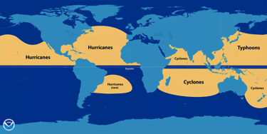
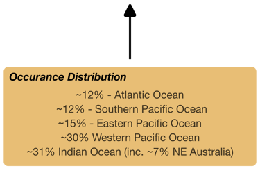
So why the different names? It all depends on where the storm forms:
Hurricanes grow in the North Atlantic, Northeast Pacific, and South Pacific.
Typhoons spiral through the Northwest Pacific.
Cyclones swirl through the Indian Ocean and Southwest Pacific.
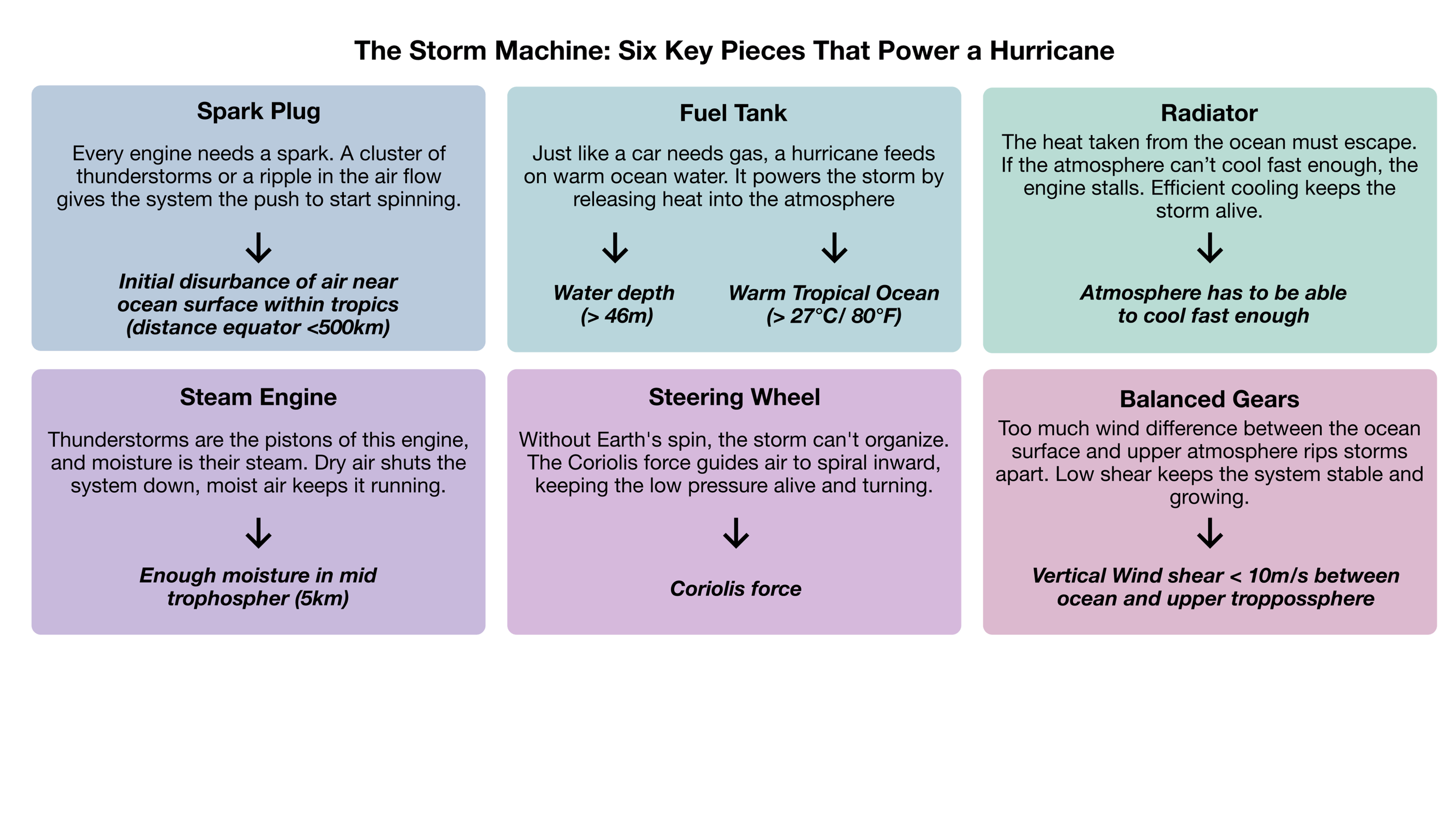
No matter the name, the process behind these storms is the same. And just like any well-oiled machine, it takes a few key pieces to get it running...
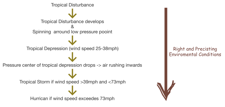
When all the right pieces come together, a tropical disturbance can grow into a full-blown hurricane. But it is important that those environmental conditions are persistent. If the atmosphere changes too quickly, if the ocean cools, dry air flows in, or wind shear increases, the storm can stall or fall apart.
Once a hurricane is fully formed, though, it usually keeps going until it hits land. That's where its two main power sources, heat from the ocean and moisture in the air, get cut off. In other words: the fuel tank runs dry, and the steam engine shuts down.
Credit: NOAA
Credit NASA

Forecasting hurricane activity is a complex task, and over the years, scientists have developed different ways to measure and predict how intense a season might be. Two of the most commonly used metrics are the ACE Index and the TIKE Metric.
ACE (Accumulated Cyclone Energy) Index
This index looks at the number, strength, and duration of all tropical storms and hurricanes in a season. It combines frequency and intensity into one score, giving an overall picture of how active a season is.
TIKE (Track Integrated Kinetic Energy) Metric
Unlike ACE, which focuses on maximum intensity, TIKE takes into account both the strength and size of each storm. It’s designed to better reflect the potential for widespread impact, especially from large systems with strong winds, even if they aren’t classified as the most intense hurricanes.
Forecasts using these metrics come from leading institutions around the world, including:
NOAA
UK Met Office (National Weather Service)
Colorado State University’s Tropical Meteorology Project
North Carolina State University
University College London’s Tropical Storm Risk Consortium
AccuWeather (commercial forecaster)
2025 Hurricane Season Outlook – Colorado State University
According to the latest forecast by the Tropical Meteorology Project at Colorado State University (CSU), the 2025 Atlantic hurricane season is expected to have above-normal activity.
The CSU team notes that current La Niña conditions are likely to shift toward ENSO-neutral in the coming months, though there's still uncertainty about what the ENSO phase will be by late summer and fall. In addition, sea surface temperatures across the central and eastern Atlantic are warmer than average, though not as warm as this time last year.
This combination, a warmer tropical Atlantic and a possible neutral or La Niña pattern, creates favorable conditions for the formation and strengthening of hurricanes. Based on these indicators, CSU anticipates an above-average probability of major hurricanes making landfall in both the continental U.S. and the Caribbean.
Resources
[1] Bang, H.N., Miles, L.S. and Gordon, R.D. (2019) Hurricane Occurrence and Seasonal Activity: An Analysis of the 2017 Atlantic Hurricane Season. American Journal of Climate Change , 8, 454-481. https://doi.org/10.4236/ajcc.2019.84025
[2]Nelson, S. (2014) Tropical Cyclones (Hurricanes).http://www.tulane.edu/~sanelson/New_Orleans_and_Hurricanes/tropical_cyclones.htm
[3] WMO (2016) Regional Association I-Tropical Cyclone Operational Plan for the South.
[4] UKMetOffice (2018) Tropical Cyclone Facts. https://www.metoffice.gov.uk/research/weather/tropical-cyclones/facts
[5] NOAA (2018) What Is the Difference between a Hurricane and a Typhoon? https://oceanservice.noaa.gov/facts/cyclone.html
[6] Henderson-Sellers, A., Zhang, G., Bertz, G., Emmanuel, K., Gray, W., Landsea, C., Holland, G., Lighthill, J., Shieh, S., Webster, P. and McGuffie, K. (1998) Tropical Cyclone and Global Climate Change: A Post-IPCC Assessment. Bulletin of Amer i-can Meteorological Society , 79, 1649-1668. https://doi.org/10.1175/1520-0477(1998)079<0019:TCAGCC>2.0.CO;2
[7]Hart, R. (2006) Hurricanes: A Primer on Formation, Structure, Intensity Change and Frequency. http://icecap.us/images/uploads/409.pdf
[8] Kerry, E. (2007) Environmental Factors Affecting Tropical Cyclone Power Dissipation. Journal of Climate , 20, 5497-5509. https://doi.org/10.1175/2007JCLI1571.1
[9] Mark, S. and Lea, A. (2008) Large Contribution of Sea Surface Warming to Recent increase in Atlantic Hurricane Activity. Nature , 451, 557-561.
https://doi.org/10.1038/nature06422
[10] NASA (2018) How Do Hurricanes Form? https://spaceplace.nasa.gov/hurricanes/en
[11]Sriver, L. and Huber, M. (2007) Observational Evidence for an Ocean Heat Pump Induced by Tropical Cyclones. Nature , 447, 577-580.
https://doi.org/10.1038/nature05785
[12] Knutson, T., McBride, J., Chan, J., Kerry, E., Greg, H., Chris, L., Held, I., Kossin, P., Srivastava, A. and Sugi, M. (2010) Tropical Cyclones and Climate Change. Nature Geoscience , 3, 157-163. https://doi.org/10.1038/ngeo779
[13] Mei, W., Primeau, F., McWillams, J. and Pasquero, C. (2013) Sea Surface Height Evidence for Long-Term Warming Effects of Tropical Cyclones on the Ocean. Proceedings of the National Academy of Sciences , 110, 15207-15210. https://doi.org/10.1073/pnas.1306753110
[14] Bell, G. and Chelliah, M. (2006) Leading Tropical Modes Associated with Inter-Annual and Multi-Decadal Fluctuations in North Atlantic Hurricane Activity. Journal of Climate , 19, 590-612. https://doi.org/10.1175/JCLI3659.1
If you’d like to read more, follow our journey, and support what we do, don’t forget to subscribe to our newsletter or follow us on social media. Every bit of encouragement helps keep the adventure going and we’d love to have you aboard!