

Currents That Shape the Seas
Global Current Systems Guiding Every Voyage
4 min read
The world’s oceans are crisscrossed by a complex network of current systems that can significantly impact the route and speed of a sailing vessel. These currents are not random. They are driven by fundamental physical forces acting on the ocean water. Understanding them isn't just useful for planning passages, it's essential for any sailor.
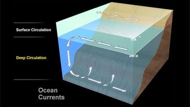
Deep ocean currents are part of what scientists call the thermohaline circulation, sometimes referred to as the “global conveyor belt.” These currents are driven by differences in water temperature (thermo) and salinity (haline), which in turn affect the water’s density. Colder, saltier water is denser and sinks, while warmer, fresher water rises. These vertical movements, influenced by gravity and density gradients, drive slow but massive flows deep below the surface. While deep currents play a crucial role in long-term climate and ocean chemistry, it's the surface currents that matter most to sailors. These currents directly affect navigation, fuel efficiency (if under power), and even safety at sea.
Surface currents are largely generated by friction between wind and water, with winds pushing surface layers of the ocean. But due to the Coriolis effect, caused by Earth’s rotation, this motion is deflected:
Right in the Northern Hemisphere
Left in the Southern Hemisphere
This deflection results in the Ekman Spiral, where each layer of water turns slightly more than the one above. The net result is that water moves about 90° to the side of the wind direction.
In major ocean basins, wind patterns and the Coriolis effect combine to create massive circular current systems called gyres (e.g., the North Atlantic Gyre or South Pacific Gyre). Because water is constantly pushed toward the center of these rotating systems, it piles up, creating a slightly elevated dome of water, sometimes a few dozen centimeters higher than the surrounding ocean. This subtle elevation generates a pressure gradient, which, in combination with the Coriolis force, helps maintain the circular motion of the gyre.
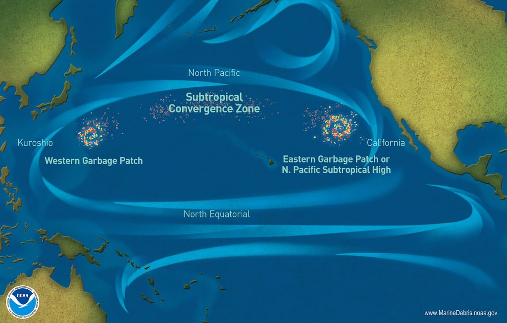
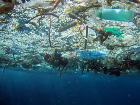
🧠 Fun fact: The center of ocean gyres has higher sea surface height and less mixing, which is why floating debris tends to accumulate there. Most famously in the Great Pacific Garbage Patch.

At the equator, however, the situation is different. Since the Coriolis effect is nearly zero there, surface waters are not deflected into circular motion. Instead, strong trade winds push surface water westward, and due to the divergence of flow near the equator (water moving slightly north and south), water tends to be pulled away from the equator, leading to a slightly lower sea surface height. This creates ideal conditions for upwelling, where deeper, cooler, and nutrient-rich waters rise to the surface.
Note: While most surface currents are stable and wind-driven, large-scale climate patterns like El Niño and La Niña can temporarily disrupt normal flow, especially along the equator and in the Pacific Ocean. These events can alter current direction and strength, making them critical for sailors to watch when planning transoceanic routes.

Ocean currents can be broadly classified into two categories:
1. Surface Currents
2. Deep Ocean Currents
Credit: NOAA
Credit: NOAA
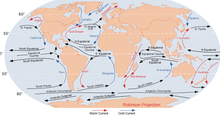
Overview Current Systems
North Atlantic Gyre : This large clockwise system dominates the North Atlantic. The Gulf Stream, its western boundary, carries warm water from the Caribbean up the U.S. coast and across to Europe. It’s fast, powerful, and often creates rough conditions where it meets opposing winds. The Canary Current, on the eastern side, flows southward along Europe and Africa, supporting traditional trade wind routes to the Caribbean.
South Atlantic Gyre: Rotating counterclockwise, this gyre supports westward sailing across the South Atlantic. The Brazil Current runs south along South America, while the Benguela Current flows north along the coast of Namibia, known for its nutrient-rich upwelling.
North Pacific Gyre: A vast clockwise circulation with the Kuroshio Current (east of Japan), California Current (down the U.S. coast), and North Equatorial Current. In the center lies the infamous Great Pacific Garbage Patch, a slow-moving zone where floating debris accumulates.
South Pacific Gyre: This counterclockwise system is vital for sailors navigating the South Pacific. The East Australian Current (The “Nemo” one!) flows south, while the Humboldt Current off Peru flows north with cold, nutrient-rich water.
Indian Ocean Gyre: Unique among gyres, the Indian Ocean system reverses direction with the monsoon seasons. From June to September, currents flow northeastward with the Southwest Monsoon and from December to March, they flow the opposite way with the Northeast Monsoon.
Equatorial Currents: Straddling the equator, these include two westward-flowing currents (North and South Equatorial Currents) and an eastward Equatorial Countercurrent in between. The countercurrent can be surprisingly strong and is often used when sailing east across the Pacific or Atlantic.
Antarctic Circumpolar Current (ACC): Encircling Antarctica, this is the strongest current on Earth, flowing uninterrupted from west to east. It's vital for anyone venturing into the Southern Ocean, around Cape Horn for instance, where it brings huge swells and extreme weather.
Agulhas Current: Running south along South Africa’s east coast, the Agulhas Current is fast and narrow. It’s infamous for creating towering, chaotic waves when southerly winds blow against it, often considered some of the most dangerous sailing conditions on the planet.
Norwegian & Greenland Currents: In the far North Atlantic, these currents bring relatively warm water into the Arctic and return cold water southward. They play a key role in ice distribution and can affect sailing routes in Greenland, Iceland, and beyond.
For sailors, ocean currents are both invisible engines and hidden obstacles. They can boost your speed, slow you down, or shape entire passage routes. Understanding them helps with planning efficient voyages, avoiding foul weather, and navigating safely near coasts or major current boundaries. In some places, like the Gulf Stream or Agulhas Current, the interaction between current and wind can even create dangerous sea states, so knowing where the water flows can be as crucial as watching the wind.
If you’d like to read more, follow our journey, and support what we do, don’t forget to subscribe to our newsletter or follow us on social media. Every bit of encouragement helps keep the adventure going and we’d love to have you aboard!